Showing posts with label ADS-B. Show all posts

Tuesday, July 6, 2021

L-Band: Frequencies You Need To Know About


L Band is defined by IEEE as 1 to 2 GHz and there is a lot going on in this valuable chunk of spectrum that will be of interest to any radio hobbyist, regardless if you are an amateur radio person or not.

In the United States, the Federal Communications Commission (FCC) visualizes L-Band like this:


Lets take a quick look at what to expect via some easy to monitor targets as single discrete frequencies:

  1. 1030 MHz ( ADS-B Interrogator)
  2. 1090 MHz (ADS-B/1090ES)
  3. 1176.45 MHz (GPS L5 & GLONASS L5OCM & Baidou B2a  & NavIC L5)
  4. 1191.795 MHz (Baidou B2a/B2b)
  5. 1202.025 MHz (GLONASS L3OC)
  6. 1207.14 (GLONASS L3OCM  & Baidou B2I/B2Q)
  7. 1227.60 (GPS L2)
  8. 1246 MHz (GLONASS L2)
  9. 1248.06 MHz (GLONASS L2OC & L2SC)
  10. 1268.52 MHz (Baidou B3I/B3Q/B3A)
  11. 1294.0 MHz (Amateur Region 3 FM Calling)
  12. 1294.5 MHz (Amateur Region 2 FM Calling)
  13. 1296.1 MHz (Amateur Region 2 CW/SSB Calling
  14. 1296.2 MHz (Amateur Region 1 CW/SSB Calling
  15. 1297.5 MHz (Amateur Region 1 FM Calling)
  16. 1381.05 (GPS L3)
  17. 1420 MHz (Hydrogen Line)
  18. 1544.5 MHz (COSPAT-SARSAT)
  19. 1561.098 MHz (Baidou B1Q)
  20. 1575.420 MHz (GPS L1 & GLONASS L1OCM  & Baidou B1C/B1/B1A)
  21. 1600.995 MHz (GLONASS L1OC & L1SC)
  22. 1602 MHz (GLONASS L1)
  23. 1691.0 MHz (GOES-10 WEFAX & MeteoSat & GMS)
  24. 1685.7 MHz (GOES-10 GVAR PDUS  & GOES-12 GVAR PDUS)
  25. 1694.1 MHz (GOES-16 HRIT/EMWIN & GOES-17 HRIT/EMWIN)
  26. 1698 MHz (NOAA-16 HRPT & NOAA-12 HRPT)
  27. 1702.5 MHz (NOAA-15 HRPT)
  28. 1707 MHz (NOAA-17 HRPT & NOAA-14 HRPT)

There is much more more beyond the above list worth looking at, but to do so, you need the right receiver and the right antenna to get started.

Your first L-Band Receiver

This is the easiest part to buy, but will get more complicated later on.  

Purchasing an inexpensive software defined radio USB dongle like a genuine RTL-SDR v3 will offer the most flexibility to experiment with for L-Band monitoring. Why?

  • Costs less than $40 USD
  • Can be repurposed for monitoring frequencies outside of L-Band
  • Can resolve signals up to and between 2.4 MHz and 3.2 MHz bandwidth
  • Relatively stable accuracy across entire tuning range thanks to its 1 PPM TCXO
  • Has a low power DC bias injector needed for some external amplifiers or antennae
  • Easy to locate closer to antenna or computer depending on application because of its USB and SMA connectors.

Many of the signals found in L-Band are data communications versus voice modes like N-FM or SSB, so using an SDR is the best way to get started.

Your first L-Band Antennae

This is a tough thing to address since an antenna at L band frequencies will have different benefits or shortcomings depending on what you wish to monitor.

With most applications for L Band focused on directional or space based communications, a pre amplified or passive patch antenna is a good way to start out as well as to try a single plane Yagi antenna.

Currently my "favorite" antenna for a large and interesting portion of L Band is made by the same folks who make the popular RTL-SDR V3 USB device mentioned above.  

Covering 1525 to 1660 MHz, this amplified antenna is very nice and comes with a length of cable and mounting options. Purchase direct from RTL-SDR.com or via Amazon here.


While the nice suction and gripper base are included with the antenna, I found them personally a little annoying so instead for portable demonstrations, I am using this inexpensive tripod that extends up to almost 4ft tall and collapses down very small. And, it comes with some other accessories that made it an even better deal. 


There are many other options for specific portions of  L Band to consider especially if you are interested in ADS-B aircraft signals at 1090 MHz or the amateur radio portion of the band from 1240 to 1300 MHz but we are not going to focus on those in this article. 

Your first L-Band Software

There are so many options, but here is a list of the top options worth having on hand.

General Purpose:  SDRangel - This great and under appreciated software offers a lot if you are interested in L-Band monitoring. Built in mapping for ADS-B at 1090 MHz plus some helpful satellite prediction and visualization tools along with digital television options are a few examples. 


SAR & Navigation: Tekmanoid EGC/LES STD-C Decoder - If you are interested in decoding InMarSat satellites which are used for maritime shipping and safety along with some aircraft or search and rescue situations, this may be of interest.


High Resolution Weather:  XHRPT, HRPT Reader, HRPT Decoder for HRPT as well as GOES imaging are a few options ranging from free to paid software. 

There are enough videos and articles elsewhere that talk about how to set up this high resolution weather decoding using the 1.6 GHz range spectrum within L Band. Many people find success with repurposing  2.4 GHz Wi-Fi grid antennae with a simple modification or a purpose made 1.7 GHz version. 

HRPT satellite   HRPT satellite


Amateur DATV:  SDRangel - This program is great for many reasons, but one area to use it for is decoding different analog and digital video signals. A typical DVB-S2 signal is less than 300 kHz wide and using the 23cm amateur band using a Lime SDR or HackRF is a great way to experiment along with DATVexpess to transmit with, and use SDRangel to receive.


Summary

This article is not meant to be an exhaustive how to article, but to raise awareness of L Band and for the amateur radio crowd, to see how in demand this spectrum is and to find ways to utilize the 1240 to 1300 MHz allocation in the United States before commercial services further try to purchase this spectrum. 

Sunday, March 7, 2021

Coming 2 ADS-B Again


Published back on February 17th 2021, my article on "Analyzing Frozen Air Traffic in the Hudson Valley" got some attention thanks to the most excellent RTL-SDR.com blog a few days later. 

Today I was inspired to write this follow up after returning from a COVID safe family trip down to Arden Point this morning after hearing (and seeing) a United States Coast Guard HC-130J overfly our position this morning around 10:30 AM local Hudson Valley Time (HVT).  This volkssport activity helped clear our heads after watching Coming 2 America the night prior. 

Sadly the above photo is a stock photo and not of the actual USCG aircraft that overflew us while enjoying the nature just to the south from United States Military Academy at West Point, as shown here on APRS.fi 

Comparing Visualized Data

The author of graphs1090 named weidehopf of whom I used the graphing software to generate the charts in my original article sent me a private message to adjust my gain downward and find a balance between messages received and distance of furthest aircraft since my signals over 3dbm were WAY too high.

When I moved in 2019 roughly 20 miles south of my prior location, I mistakenly left my gain set to AGC which automatically adjusted my system gain since my antenna was not in an optimal location for ADS-B compared to what is installed now.

Changing my setting from the default AGC to a figure of 24, here is the before and after difference in received messages. No adjustments to the hardware or antenna have been made.


It is a pretty remarkable difference in number of total ADS-B messages received, almost 2.5x times more in fact.  

But, usually there is a trade off when it comes to maximizing the distance received and is something I have intentionally tried to manipulate so as to avoid some of the heavier airtraffic to my south via KJFK and KLGA worrying that my receiver may get flooded with too many messages. 

For the same calendar period as above, here is the results by reducing my gain.

So for the first few days after adjusting my gain much further, I raised it up ever so slightly based on the guidance of weidehopf via the information found in that Git repository along with further reading on the FlightAware message boards. 

I found my perfect balance of messages, aircraft and range now, so thanks for that tip. 


You can see here the signal levels and where I made my initial adjustments and then increasing them slightly after a few days where I found the perfect setting which has been untouched for the last two weeks in the below chart.


The most important benefit to optimizing the gain setting aside from drastically increasing my total messages received has also been a boost in Raspberry Pi performance. 

The total CPU usage has decreased a good amount which also lowered the core temperature during certain times of day.


Since I am only using passive cooling via a heat spreader and metal enclosure, my maximum core temperature now seems to track against major peak times of ADS-B traffic rather than stay at a more steady level. 

This may be interesting to reevaluate once summer temperatures arrive given the receiver is located in my attic for maximum height without going outside due to diminishing returns for effort needed as mentioned in past via Line Of Sight: Aircraft Edition.


If you missed it, the moral is, more gain is not a good thing. Use a visualization tool like that offered by Graphs1090 to fine tune your ADS-B system for maximum benefit and enjoyment. Hope you enjoyed this explanation. Here are some past ADS-B related HVDN articles...

Wednesday, February 17, 2021

Analyzing Frozen Air Traffic in the Hudson Valley


Ever wonder where airplanes are headed to and from?  The easiest way to figure this out is by spending about $30 for an inexpensive USB software defined radio (SDR) receiver and a small antenna designed to receive signals at 1090 MHz globally and 978 MHz in the United States. These systems are called ADS-B and UAT with some more details here.


The above chart shows all air traffic for about the last 30 days in the Hudson Valley as seen by the main HVDN ADS-B receiver located in Poughkeepsie. 

See that huge drop off of air traffic on February 1st and 2nd?  That is easily explained by that HUGE snow storm that dumped more than two feet of snow across the region which the Overlook Mountain Amateur Radio had a constant weather reporting discussion on its wide area 146.805 MHz repeater locally here in the Hudson Valley. 

While that chart only shows the number of transmissions made by aircraft that you can receive with something like the genuine RTL-SDR v3  or the optimized ADS-B version by Flightaware, here is what that looked like for actual individual aircraft. Sure looks like UPS and Fedex flying in and out of KSWF were busy just before the white stuff closed the airport.


Analytics & SDR 

Any hobby that involves some sort of radio communication is a great way to also learn about database management, data visualization and data capture. 

Keeping a Raspberry Pi computer nice and cool is important if you will be doing anything compute intensive and here is a view of the internal temperature of the one running the ADS-B receiver up in Steve K2GOG's attic.   Given how cold its been the past month, we can easily see it benefited the processor core temperature.


All these great charts and many more like it are courtesy of the Graphs1090 application that can run on a Raspberry Pi along with the ADS-B (1090 MHz) and UAT (978MHz) receiver software. 

Special care long term needs to be taken though in storing data long term though since a standard SD card may get corrupted over time due to so many read/write cycles. Another lesson being learned in real time. 

With the simple antenna and receiver, here is a visualization of the range of the receiver Steve has set up and shows four different tiers of range between different altitude boundaries.


The inner most plot is for historical range received by any aircraft below 9999 feet and outermost red colored plot is for aircraft traveling 30000 feet or higher.

As covered previously in the "Line of Site: Aircraft Edition" article, there is not much that can be improved upon unless the antenna is moved much much higher, and is thus a point of diminishing return for the effort versus benefit gained.

You may notice not a omnidirectional pattern and that is due to a mountain range to the north west of the receiver location and a lower amount of air traffic in that general direction.


The above collection of charts shows just the air traffic over just a two day period between February 15 and the exact time of this article's publish time. Its pretty clear when there are more aircraft flying around, how far they are detected and even the signal level received.  

For the most part, if there is an aircraft traveling in the Hudson Valley area, Steve's receiver can hear it!

The only way to improve the system is by placing other receivers at other locations and sharing that data in real time into the HVDN Locator tool built upon Virtual Radar Server.

Its easy to  combine multiple receivers into one view and even go back and filter what each receiver was able to hear by itself or as part of the wider network. 

If you live somewhere in the Hudson Valley region and would like to set up your own receiver that can feed into the HVDN Locator project, please consider becoming an HVDN member and/or drop a note into our HVDN Slack channel.  Our system is only made publicly available during certain times of the day, whereas during other times, only our members can access the system. 

The system even supports live weather data being pulled into the system too, which is fun to watch in real time as air craft need to change altitude to dodge storms, plus see how often specific aircraft hit crappy conditions by using the report generation tool found in the upper left hand menu drop down.

An example of a report is looking at historical military aircraft received by visiting milair.hvdn.org. 

Getting an understanding of who is flying around allows for much easier audio monitoring on VHF and UHF channels that will be covered in future articles.


Friday, November 20, 2020

2020 Update: Using SDRangel with Windows 10 (Basic Overview)


Before HVDN was even a thing, I did a video explaining how to get SDRangel software running under Microsoft 10. I am pretty surprised it is up to over 18,000 views and many people have asked for an update since. 

Three years ago,  Edouard Griffith's project was up to version 3.8.5 and today we are up to version 6. Much has happened since 2017 with SDRangel development, so lets see how easy it is to use this great piece of software.

Getting Started: 64 Bit Computer!

I can not stress this enough, especially to frugal hobbyists like those involved in amateur radio - YOU NEED A 64 BIT COMPUTER!!  For SDRangel to run correctly, it is time to ditch that bargain basement Windows XP, Vista or 7 vintage computer that was based on 32 bit architecture. 

Complaints about SDRangel usually are based on a poor user experience that starts with an improper computer.  Much hard work has gone into a this great software and the developers deserve a lot of credit.

Back in 2017,  a 64 bit computer was still considered standard, but many were still using older machines. The costs for a modern computer have come down, so please look for a deal on a good 64 bit computer with multiple cores and lots of RAM. You will thank me later when it comes to SDRangel experiences.

What can you do with SDRangel?

Installing SDRangel is now even more easier since about version 4 when precompiled executables started to become available in the SDRangel Git repository.  My latest video reviewing version 6 shows how easy it is to set up and use with a basic genuine RTL-SDR.com V3 USB receiver. 

Feel free to check it out on our YouTube channel and look forward to a few other videos about how to use the transmit and other receive features with appropriate SDR's like a Lime SDR Mini.  

Also, be sure to have a look at what Sarah from SignalsEverywhere is going if you are interested in DATV and all things SDR related too!


Saturday, August 24, 2019

New York Air Show 2019 Details


The 2019 New York International Air Show is ready to begin Saturday August 24th. Here are the important visual and audible details to know for the 2019 event taking place at Stewart International Airport in Newburgh, New York.

2019 scheduled performances include, in performance order:
  • United States Military Academy West Point Parachute Team
  • Mike Wiskus Opener
  • Chuck Dramamine
  • L-39 Jet Demo (ADE743 N995X)
  • B-25 Bomber "Panchito" (AC8CD8 N9079Z)
  • Matt Chapman (A39643 N330ER)
  • The GEICO Skytypers (A89B45 N65370  &  A09468 N1364J plus 4 more)
  • British Royal Air Force Red Arrows
  • Mike Wiskus in the Lucas Oil Pitts
  • Kent Pietsch - How to land on an RV
  • United States Air Force F-35A Lightning II
  • P-51A (A577DC N451WW)
  • Michael Goulian 
  • Kent Pietsch - How to land with no engine
  • United States Navy Blue Angels
Last minute scheduled performers
  • New York State Police Helicopter
  • UH-72 Mighty Lakota Helicopter

Select aircraft on the ground on display will include:
  • A-10 Warthog (AE1904 79-0139 or AE18F5 79-0111)
  • C-130 Hercules
  • C-17 Globemaster III
  • F-16 Viper
  • AH-64 Apache
  • Airbus A400M  (43C5ED RRR4027)
  • F-15 Eagle
  • UH-72 Lakota
  • More....
*Will update this article with ICAO & Tail Number after attendance

Event Parking


Notices to Airmen (NOTAM)

Restricted airspace is in effect with details here:  https://tfr.faa.gov/save_pages/detail_9_2689.html


Radio:  Listen to the performers

Below is a listing of operations and main performer related frequencies in use at the event. Unless otherwise noted, all are in AM mode.

Stewart International Airport
  • UNICOM: 122.95
  • ATIS: 124.575
  • STEWART GROUND: 121.9
  • STEWART TOWER: 121.0 & 254.4
  • NY APPROACH: 132.75
  • NY DEPARTURE: 132.75
  • ANG COMMAND POST: 139.7 & 361.4
  • AR OPS: 126.2 & 38.2 (FM)
Past NY Airshow Operations 
  • INFORMAL CHAT & AIRBOSS: 123.425
  • AIRBOSS: 135.650
  • SHOW OPS: 237.8
  • SHOW OPS: 284.250
  • SHOWS OPS: 275.350
  • SHOW OPS: 379.400
  • SITE REPEATER 453.475 (FM)
  • SITE REPEATER 453.975 (FM)
United States Navy Blue Angels
  •   ALPHA 139.8125 (FM)
  •   BRAVO 142.6125 (FM)
  •   ATC OBSERVER 143.0000
  •   AIR TO AIR & GROUND SUPPORT143.6000
  •   TOWER COMM CART 173.8250 (FM)
  •   OLD FREQ 236.4500
  •   AIR TO AIR / XCOUNTRY / SOLOS / DELTA 237.8000
  •   AIR TO AIR / XCOUNTRY / DIAMOND 238.1500
  •   SOLOS 249.6500
  •   SOLOS 251.6000
  •   SOLOS 254.5000
  •   DELTA 255.2000
  •   DIAMOND / FAT ALBERT 263.3500
  •   DIAMOND 264.3500
  •   DIAMOND 264.5500
  •   DIAMOND 265.0000
  •   STARTUP / FAT ALBERT 273.3000
  •   STARTUP / DIAMOND / DELTA 275.3500
  •   AIR TO AIR / XCOUNTRY / STARTUP / DIAMOND 284.250
  •   AERIAL REFUEL 289.8000
  •   DIAMOND 299.6500
  •   FAT ALBERT SECONDARY 302.1000
  •   SOLOS / FAT ALBERT PRIMARY 305.5000
  •   DIAMOND 307.7000
  •   SOLOS 345.9000
  •   SOLOS 346.5000
British Royal Air Force Red Arrows
  • A2A 243.450
  • A2A 242.200
Radar:  Tracking Aircraft

As long as aircraft are transmitting location data via ADS-B, they will appear on the below map along with user selectable weather and airspace. No access password is required for the airshow duration.  Access will return to normal password protected operation Monday August 26th 2019.
  • locator.hvdn.org
  • Please note that there is no airboss frequency streaming this year available on HVDN

Saturday, July 13, 2019

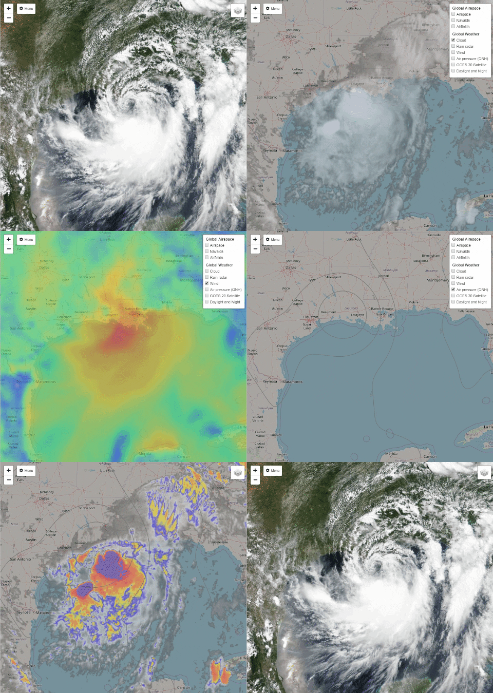
Tropical Storm Barry: Weather & Aircraft

Hudson Valley Digital Network (HVDN) integrates various real time weather imagery into our ADS-B based air traffic server detailed here.  Currently, the Hudson Valley is experiencing beautifully clear weather this weekend which is great for flying.

However, the Gulf Coast area soon to be affected by Tropical Storm Barry will not share this with us here in New York.

Current imagery generated at 16:30 Eastern Time, July 13th 2019.

For access to the HVDN ADS-B system with integrated weather feed, please consider making a small donation. Proceeds collected over the next week will be aggregated and donated to a deserving organization in the storm affected area. All who donate will receive 6 months of HVDN ADS-B access.

The HVDN membership hopes those in the storm affected area will be safe once the storm makes landfall.


Thursday, July 11, 2019

Yaesu FT-3 Instruction Manual Review


Perhaps HVDN will start a new trend where we do a review of instruction manuals and everyone else follows along. Lets start this amazing idea off with the FCC approved Yaesu FT-3 radio manual now available.

FCC ID:  K6620725X20 Manual Review

So many products today in amateur radio land almost seem to ship with little documented information on how to use them.  As digital voice radios continue to get more complex, there are "certain vendors" that do not put any effort into a decent instruction manual.

Yaesu is one vendor that actually does put forth good effort in trying to document almost every function, quirk and specification possible, so we thank you very much for that.

This article will hit on a few interesting nuggets found in the new Yaesu FT-3 C4FM capable dual band hand held radio.  We will not discuss the "how to install the battery or hand-strap" unfortunately.


As predicted with absolute precision all the way back on May 28th 2019 in our "FCC Update:  FT-3 cleared for launch" article, the instruction manual would be made public for our eyes to gawk at on July 10th.  A much better version will soon appear on the Yaesu website though, so please be aware of that.

This basic manual is not even available on Yaesu's website yet.  For anyone ever complaining about government dysfunction, the person responsible for pressing buttons at the FCC is doing a great job.


 Lets Review Page....


The really fantastic thing about page 11 is that Yaesu is pretty much telling us specifically that battery life will be near horrible with this radio just like the brochure pointed out so we all knew what we were in for after the $500 investment involved in acquiring a Yaesu FT-3.

For those interested in UHF operation, perhaps changing over to VHF would be a better experience for anything requiring slightly better battery life.  The Yaesu FT-3 out of the gate sounds like a great radio to mostly listen versus talk for any length of time, which is OK because most repeaters have very little traffic on them these days or do they?


This is the Yaesu FT-3 radio that this
article is focused on, of course.


Who ever is selling VHF capable hot spot devices should increase prices now to reap the benefits of Yaesu publishing this specification.  Quite a bit of activity can be discovered globally by using a Fusion radio with a device like one of many Pi-Star based MMDVM devices or the Open Spot 2.

The older Yaesu FT-2 battery will also fit the FT-3 which is nice, so stock up on those now before those get scarce in case third party vendors stop selling them or stocking aftermarket versions.

This is the Yaesu FT-2 which lacked C4FM
and a color screen found on the new FT-3


Vendors who sell the Anytone, TYT and Radioddity gear have for a few years now been running great deals on packages that include a spare battery, but we will likely never see Yaesu, Kenwood or Icom ever do something like that even if you purchase a $500 USD radio.

The last note on battery life is,  do not go anywhere with your new radio. The manufacturer is clear that any disturbance such as a warm fart or brief trip to the outhouse while playing ham radio may reduce the life of your battery.

The ability to receive in AM mode is actually a major benefit so that you can listen to aircraft communications in the VHF 118-136.995 MHz portion.  There is no voice communication in the 108  to 118 MHz segment as that is reserved for navigational aids.

The "hidden feature" is the ability to swap to AM in the 138 to 144,  148 to 150 MHz for military "air to air" or "air to ground" communications.   The same holds true within the 225 to 400 MHz band which is considered the domain of military operations around the world, including these big guys flying out of Stewart Air Force Base right here in the Hudson Valley of New York and tracked using the HVDN ADS-B monitor.  The FT-3 can only monitor voice transmissions in the above mentioned frequency range and not the 1090 MHz or 978 MHz transponder signals which is what ADS-B is for.


Not everything in this band segment is AM though, so having a look at the UHF Satcom website for other ideas might not be a bad idea when there is no activity on the 2m and 70cm ham bands.

Compared to the Kenwood TH-F6 and TH-D74, there is no SSB mode on the Yaesu FT-3, so HF monitoring will be limited to only AM broadcasters or the rare AM enthusiast on the 80m or 10m bands.

Lets skip ahead a bunch of pages to talk about a feature involving the use of Yaesu Fusion which is the digital voice mode they have adopted.  The above graphic shows some interesting use cases for the advanced calling function which may help use one frequency for many users at the same time.

In the 1990's there were many radios by different vendors that offered selective calling features not too different than this. Yaesu is touting this as a major feature of the FT-3, but your use will be limited to only people with a Yaesu radio with the same feature.

Back in the day for example, the Yaesu FT-530 was top of the line and funny enough, commands a price used on par with that of the FT-3 smaller sibling known as the FT-70. Neither new radio supports the cool external display speaker microphone though, but the FT-3 does have an option for a microphone that can take and send pictures, with images view-able on the color screen on this latest Yaesu radio.

The FT-530 was a great radio.
Does it not look like fun to use?


Right now the only other handheld Fusion radio is the FT-70, which retails for less than $160 USD and offers all the same C4FM functionality as the $500 FT-3 radio.  It is not clear if these extra selective calling features or picture sending option will help sell these radios except if there are groups buying in bulk and require these functions for some reason along with the appropriate accessories.


Here is more detail on calling functions in the menu system along with a really nice abbreviation for "Weather Alert"  which is a US market only feature that will certainly see more use compared to the different squelch, DTMF and Bell features. For analog FM ham radio use,  tone and to a lesser extent, DCS will also see a lot of use for FM analog repeater use.


There is plenty of detail on one of the stand out features of the FT-3 which sets it apart from the FT-70 which is APRS. Using 1200 baud data packets, the user can exchange location details with other users along with sending text messages. The APRS feature set can be used to communicate to any APRS radio including those produced by Kenwood, Alinco, Icom and the new Lanch HG-98 radio at a very affordable price.

Its worth noting that the FT-3 can store multiple paths for APRS which is helpful for those interested in satellite communications and may use "ARISS" to bounce off the International Space Station digipeater when it is powered up or any of the APRS capable LEO satellites such as NO-84, NO-44 and PSAT2. 

The FT-3 is also capable of high speed 9600 baud APRS  which is what Falconsat3 uses and requires a path setting of PFS3-1 rather than the normal WIDE1-1, WIDE2-1 settings for ground based use.


Have you ever wondered what the "Mode of Emission" is and why a vendor can not simply decode it for us to understand what they are for?  Here is what modes the Yaesu FT-3 can decode for your listening pleasure:

  • F2D means (F) Frequency modulation + (2) One channel containing digital information, using a subcarrier + (D) Data transmission, telemetry or telecommand (remote control).  This all works out to the so called C4FM Fusion mode but could also apply to APRS signals too.
  • F3E would work out to (F) Frequency modulation + (3) One channel containing analog information + (E)  Telephony (voice or music intended to be listened to by a human).  This is also known as "analog FM"
  • F7W to close out means (F) Frequency modulation + (7) More than one channel containing digital information + (W) Combination of any of the above. This means the FT-3 could while using C4FM based Fusion could handle some sort of data and voice at the same time but split across multiple channels. 
While that helps understand what can be received, on transmit the FT-3 has even more to offer as we will soon see.


Beyond the already explained F2D, F3E, F7W modes the Yaesu FT-3 can also transmit F1D which is frequency modulation with (1) One channel containing digital information, no sub-carrier and (D) Data transmission, telemetry or telecommand (remote control).  This is what APRS is technically defined as.  The F7W mode is also defined as 4 FSK (C4FM) which is the fancy way to name Fusion.

What did we miss?

What I was really hoping to learn was possible to do some level of programming remotely via bluetooth of this new radio.  Right now, that looks like a big fat no and a reason that the Kenwood TH-D74 is a good purchase even though it supports D-Star, also known as F7W but totally different.  The Kenwood can however receive J3E, A3E and A1E modes.  You can look those up right over here thanks to Wikipedia.

The advanced FT-3 user manual

Lets just stop right there. The advanced manual is not yet out, but why not go out grab a copy of the existing basic manual from the FCC, Yaesu website or better yet, right here for convenience since we know you will not really read it anyway.


Friday, May 24, 2019

LimeSDR Mini & SDR#: Yes, it works....


Of all the SDR programs, SDR# still holds a special place in my heart. Until recently, it was hard to get the LimeSDR Mini working with this versatile piece of software.

Lucky for us, Goran Radivojevic (YT7PWR) has done some recent great work to make these two software defined radio things play nice together.

Step 1:  

DownloadSDRSharpLimeSDR_v02.zipfrom https://github.com/GoranRadivojevic/sdrsharp-limesdr/releases and unzip the folder content into where your version of SDR# is found. There are 3 files:


Step 2: 

Add the following line in the frontendPlugins sections of FrontEnds.xml file:

<add key="LimeSDR" value="SDRSharp.LimeSDR.LimeSDRIO,SDRSharp.LimeSDR" />


Step 3: 

Plug your LimeSDR Mini and load SDR#.  I am using release 1700. You should see LimeSDR in your drop down options under "Sources" just like where you would select RTL-SDR (USB).


HVDN ham radio SDR


Step 4: 

Click on the gear icon to open the setting for the LimeSDR Mini and hit the "refresh" button.  You should see the details for your LimeSDR Mini come up as pictured below.


YT7PWR K2GOG


Comments:

With the LimeSDR Mini attached to a laptop via a 6 foot USB cord, reception was fine with my "test setup". The signals shown on SDR# for the curious were two of my MMDVM hotspots operating on 427.585 MHz single slot  and 427.545 MHz dual slot running DMR mode. I pipe audio out of SDR# into DSDplus, but generally I prefer the simplicity of using SDRangel for decoding digital voice modes. Dragorn of Kismet fame printed the nice case for my Lime SDR Mini a while back.

Lime SDR Mini printed case


Steve K2GOG

-----

Recent HVDN Notebook articles worth a look: 


Tuesday, May 14, 2019

Line Of Sight: Aircraft Edition


Definition: Line of Sight

Aircraft and radio waves are two great examples to talk about regarding line of sight.

Simply put, the higher the aircraft flies, the further a ground station can receive transponder signals at 1090 MHz or 978 MHz originating from an aircraft.  Obstructions on the ground such as mountains and tall buildings can obstruct the ability to receive all ADS-B transmissions at the ground level too.

The technology covered in this article is known as automatic dependent surveillance broadcast or ADS-B for short. A fancy GIF animation at the end of this article will help visualize reality from theory even further!

Compare:  Fact and Fiction   

The website "Hey, What's That!" is useful for identifying mountain peaks and line of sight for different forms of communication. The below map shows the theoretical range of ADS-B communications up to 10,000 and 30,000 feet elevation from the chosen center point at a known height.

Poughkeepsie aircraft hobby remote control plane drone

Ground based obstructions have been accounted for on the map as noted by some local summits with the red push pins that make for great amateur radio SOTA destinations. 

A calculation of 47 foot above ground level for a total height of 256 feet was used for the same latitude and longitude coordinates six digits past the decimal point on the "Hey, What's That!" website in order to match the location of the HVDN ADS-B antenna location with high accuracy.

boeing aircraft KPOU IBM helicopter
The "Blue" center dot clearly is not in the center. of the reception range. Its location was moved to calculate the distance to all aircraft from where I was located while I was authoring this article. This is one of many features available to those that gain access to the HVDN VRS. Details about HVDN membership can be found at the end of the article.

Comparison of the theoretical and real world values are very, very close when looking at both data sources.

Had the ADS-B antenna been located outside and above the roof line just a few feet higher, its possible that the two results would have been even closer.

The dark red "splat" is the historical reception report over time for aircraft up to 30,000 feet. The pink splat is for aircraft under 10,000 feet.

However, there is one thing to take in mind here, aircraft are not flying in every possible location which will account for some gaps in coverage when looking back at the theoretical map.

Is it worth the extra work in adding an outside antenna to gain the additional coverage benefits? This certainly is shaping up as a classic case of diminishing return, so read on to show how this was validated.

Detail:  Spot checking some results

The top photos are captured from the "Hey, what's that!" website for theoretical "potential" results. The lower photo is zoomed in from the HVDN Virtual Radar Server to complete the comparison against fact to cover real life reception results.

10,000 Foot Elevation Connecticut Comparison:   The projected range spike towards and over Springfield was accurate from the projection and actual reception results.

Add caption

30,000 Foot Elevation Finger Lakes Comparison: Coverage was just short of the prediction over Cayuga Lake, but awfully close.

hvdn

10,000 Foot Elevation Long Island East End Comparison: Coverage fell short of the North Fork at 10,000 feet but air traffic is captured as noted by pictured aircraft which were at 14,000 and 18,000 feet pictured to right of coverage overlay.

hamptons 2m repeater hVDN

30,000 Foot Altitude Over Delaware Bay Comparison: Coverage was pretty accurate based on traffic spikes compared to theoretical results.


Further Results:  Comparing Other ADS-B Feeder Sites

According to Flightaware's website, there are a number of close proximity feeder sites to where the HVDN primary site is located in the Hudson Valley of New York.


Only the two highlighted receivers on the map (Orange) have similar coverage of HVDN which must mean that the height above sea level for all three stations must be similar and may even be using near identical reception equipment to that of HVDN (Red)

Here is further evaluation of the public details each of the three stations provide.

Receiver Site #1:  Montgomery, NY - Flightaware 87114


Receiver #2: Poughkeepsie, NY - Flightaware 77960


Receiver #3: Middletown, NY - Flightaware 83104


For Fun:  What if.....

It would seem for the Hudson Valley, few interested seriously in ADS-B reception can really improve reception without a huge height increase or locating the antenna outside.

Steve K2GOG of HVDN thought it would be fun to model the benefits of increased antenna height, so check out our amazing use of animation skills below to see how much higher you need to go to literally receive every aircraft possible via line of site up to 10,000 (Orange line) and 30,000 (Blue line) feet.  

hvdn aircraft, ads-b range distance

Perhaps it may be worth while putting the antenna up another 30 feet located outside. Interested in setting up your own ADS-B aircraft receiver?  Helpful links follow:
Another approach may just be easier to recruit ADS-B feed providers to just aggregate into the HVDN Virtual Radar Server to increase the range of reception for aircraft under 10,000 feet. Contact the author if there is interest in contributing to this.